It is 7 AM, the Jeep is loaded and Chris and I are just about ready to leave on our adventure. Thoughts of are we ready? Did I pack too heavy? Too light? Did I bring the right equipment? Did I work hard enough? Is my body going to handle the thin air? We had our map of Google directions printed and hotel reservations for tonight made. We said our goodbye's and set out on road.  I could hardly believe it! We are about to hike Mt. Whitney! Our goal for the first day, Mesquite Nevada. Our plan was one good nights sleep before we hit the trail. Since we both hate to drive it made the 12 hour ride more interesting.
 I could hardly believe it! We are about to hike Mt. Whitney! Our goal for the first day, Mesquite Nevada. Our plan was one good nights sleep before we hit the trail. Since we both hate to drive it made the 12 hour ride more interesting.
  Once in Mesquite, we hit the pool had a great meal and got to bed. The next morning, Wall mart for treats and gas and set sights on Lone Pine California.
  Google maps was our guide and we made through Las Vegas with a hitch. But somewhere between Area 51 and the middle of nowhere the directions told us to turn left. This took us right to the middle of Death Valley! We knew something was wrong when our map millage told use we were 50 mile from Whitney and the signs said 150+. Yep! Google had us way off course! We made the best of! We explored Death Valley! It was Hot! At 117 degrees we high tailed it out of there. But we did get >100 feet below sea level.
Once we figured out our directions we Finely made it to Mt Whitney Portal!  The Portal sits at just over 8,000 feet with a spectacular view the surrounding mountain. There is a lake for fishing, a stream, two camp sites, a few cabins for rent and the store. The store makes the best Bacon cheese burgers and home fresh cut french fries! The breakfast is awesome! They make the biggest pancakes I have ever seen! We found our way around and got settled in. We received a briefing from the camp host about the family of Bears that lived around the camp ground and how they ripped apart a SUV for 1 candy bar a hiker left in its wrapper in the glove box! He also informed us that only 20% of the hikers summit Mt Whitney and the Search and Rescue average 5 rescues a day. He then reassured us we should do just fine!
 The Portal sits at just over 8,000 feet with a spectacular view the surrounding mountain. There is a lake for fishing, a stream, two camp sites, a few cabins for rent and the store. The store makes the best Bacon cheese burgers and home fresh cut french fries! The breakfast is awesome! They make the biggest pancakes I have ever seen! We found our way around and got settled in. We received a briefing from the camp host about the family of Bears that lived around the camp ground and how they ripped apart a SUV for 1 candy bar a hiker left in its wrapper in the glove box! He also informed us that only 20% of the hikers summit Mt Whitney and the Search and Rescue average 5 rescues a day. He then reassured us we should do just fine!
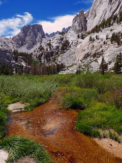
Our goal was Base Camp 6.2 miles away and an elevation gain of over 4,000 feet. It is one of the most challenging trails I have done! Relentless! But AWESOME! The view is amazing of the valley and you quickly realize how fast you are gaining elevation when you stop and look back (more like down).
 Sun rise on the mountain is unforgettable. The color of burning oranges turning to red and the deep blue sky! Truly moving! Most defiantly worth the the hike!
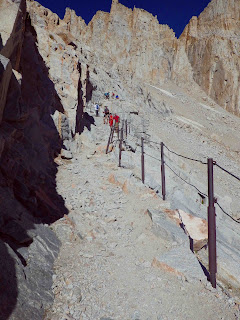
Morning came quickly! We got up and downed breakfast. After we filtered water we headed up the 98 /99 switchbacks! It was awesome! At switch back 55, I started to feel dizzy and a very light headed. I got out my pocket pulse ox and found my oxygen saturation to be at 73% and my heart rate at 156. I stoped and rested. I remember that when I was going up Kings Peak I felt the very same way. After about 1 minute my saturation's were at 90% and heart rate was now 100. I felt a lot better and continued on. My brother Dan reminded me I was caring a pack that weighted about 25 to 30# given the extra water I was caring. We made a plans to leave a water cash at the top of the switchbacks.

Once at the top of the pass I felt great! We dumped off our water cash and headed for the summit. The Views were breath taking and You felt you were on the other side the Moon.
We kept pushing. It was amazing. We passed all types of people. Age ranging from 4 to over 80 years old. Everyone very positive and excited to make it to the top. Yep we did pass people that had to turn around and could not go on. But they motivated us and gave us hope as we passed them. Once we had the view of the house in sight, we knew we could make it!

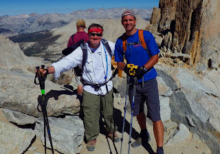
At the top we had lunch and headed back to camp. We had to deal with only one member of our party with altitude sickness and mild dehydration. Once he was doing well made good time back to camp. It was time to celebrate!. Skinny dipping in the river and dinner! It was surreal! I had meet my goal! WOW! top of the lower 48 states. 14,508 feet! It felt great! The time spent with my son Chris made it only sweeter! We both commented the only thing that would have completed this experience was if my son Scott could had made the trip.
Would I do it again? If and only if the right people came along! This was tough but the bonds of friendship made is what made it all worth it!
Hike Sat's: 22 miles, >13,000 feet of elevation change. 2 1/2 day s on the trail, 25,000+calories burned!


